Themes
Themes
An overview of our themes — land cover and habitats, water, change, biodiversity, accounts and futures.
Explore the Themes
Land Cover and Habitats
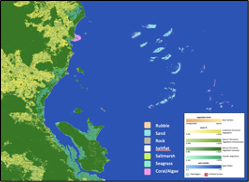
First, map and describe land cover and habitat classes from Earth observations, providing further differentiation using contextual information.
Change, Impacts and Pressures
Gather evidence for change impacts by comparing these maps and environmental descriptors used in their construction over time and then reference driving pressures.
Biodiversity
Estimate the distribution, abundance and richness of biodiversity and whether these are heading in the right direction.
Water
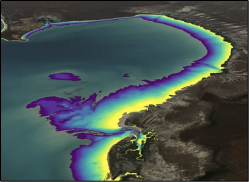
Across landscapes, water occurs in liquid form and as snow and ice, and the properties of each are multi-dimensional, relating to the surface, column or volume or substate. Respectively, these include water surface temperature and floating matter, columnar turbidity, acidity or snow grain size, and the composition and topography of the substrate. Plants and animals are also distributed on or throughout, with populations varying over space and time. Whilst the Food and Agriculture Organisation (FAO) Land Cover Classification System (LCCS) used by Living Earth allows for the classification of the different forms of water, these are relatively limited and categorical in nature. Hence, Living Earth (including through the Living Coasts, Living Watersources and Dynamic Land projects with international partners) has extended capacity to consistently describe freshwater, intertidal and marine environments from environmental descriptors retrieved or classified from Earth observation or obtained from other sources.
Future Earth
Imagining
Future landscapes and revisiting visions as needed.
Informing
Decisions by providing capacity to value landscapes (e.g., in terms of carbon, biodiversity, coastal protection, water quality).
Assessing Risk
Including from economic variations (including shocks) and climate change.
Exploring
The realism of proposed landscapes under different scenarios of change (e.g., through reference to past EO-derived knowledge and model scenarios to test proposed management interventions).
Harmonising
Viewpoints through co-design and by resolving conflicts.
Monitoring
Progress towards ambitions.