LivingEarth

  • About
    Who we are Our Projects News, Events, Research, Case Studies Publications Contact Us
  • Tools
    Overview Interactive map Get the data Analyze the data Earthtrack.app
  • Resources
    Knowledge Hub Developer Hub
  • Data
    Earth Observation Big Data and Data Cubes Enviromental Descriptors Taxonomies Living Earth Products
  • Countries
    Wales Australia
  • Themes
    About themes Land cover and habitats Water Change Impacts and Pressures Biodiversity Accounts Future Earth
Analysis Ready Data
  • Home

Analysis Ready Data

Download and pre-process satellite data to an analysis ready format.

Contact Us Contribute

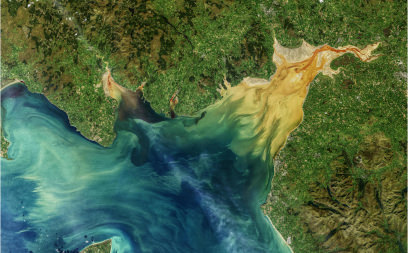
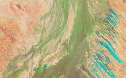
For decades, airborne and spaceborne sensors have been acquring data across all or part of Wales in varying modes and across a range of spatial resoutions and temporal freqencies. These sections provide information on and access to a range of data, much of which is in an analysis ready data (ARD) format. These include freely accessible radar and optical data acquired by the Sentinel-1 and 2 respectively, which are provided in both near real time and as historical archives and can be downloaded at no cost.

Openly available optical and radar

Provides access to Landsat and Sentinel-1 and Sentinel-2 data

Lidar
Lidar

Airborne and spaceborne Lidar

Thermal
Thermal

Thermal data

Data
Data

A list of data sources relevant to environmental descriptors in Wales

Algorithms
Algorithms

Algorithms for retreiving environmental deescriptors

Othersa
Othersa

Other Earth observation datasets

help us make change happen…

Find out how you can contribute to or collaborate with Living Earth by joining our community....

LivingEarth

sites

  • About Us
  • News
  • Jobs
  • Process
  • Past and Present
  • Future Lanscapes

Countries

  • Wales
  • Australia

Tools

  • Interactive Map
  • Get the data
  • Analyse the data
  • EARTHTRACK App Verification

Earthtrack App

© 2023 livingearth